View basket “Pre-Napoleonic map of Germany, Nuremberg 1786” has been added to your basket.
Sale!
GERMANY. A London printed map of 1788 by William Faden
£125.00£110.00
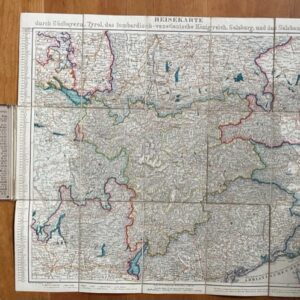
A New Map of the German Empire, and the neighbouring States and their Principal Post Roads, originally Published by the Royal Academy of Berlin. Engraved with several Additions and Improvements by William Faden, Geographer to the King. William Faden, Corner of St. Martins Lane, Charring Cross [London] 1788.
An attractive folded, dissected and linen backed map, coloured in outline, unfolding to a size of 30 x 25½ ins [755 x 560m] showing the German Empire just a year before the French Revolution and ensuing Revolutionary and Napoleonic Wars. The map folds down in 20 plates to a size of approx 8 x 5ins [192 x 135mm]. There is no slip case: the outer plates have a contemporary title in manuscript and contemporary ownership signatures.The map extends from southern Sweden in the north to the Gulf of Venice in the south and from Champagne and Picardy in the west to include much of Poland and Hungary in the east. The map is generally clean and perfectly sound. oct24/2


")


")