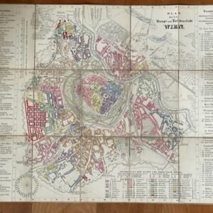
View basket “VIENNA. An attractive little plan of the Imperial Austrian Capital, 1853.” has been added to your basket.
Sale!
SAFFRON WALDEN. Robinson’s folding map of this Essex area, 1787
£90.00£70.00
A Map of the Country around Saffron Walden. Wm. Robinson, Junr. [Saffron Walden], 1787.
A folding map, coloured in outline and with some block colour, dissected, linen-mounted, extending to a size of 26¾ x 19¾ ins. The map folds down to a size of 7 x 5ins. There is no slipcase. The map is somewhat stained and soiled but really in quite good condition for a folding map of this age. The title is on an urn and pedestal scene and the engraver is identified as Neele of 552 Strand. The map has no scale or other details but covers the area of the Essex Hundreds of Uttlesford, Hinckford, and Freshwell with part of Dunmow. mar20/3