Information
Home
About Bates & Hindmarch
How to buy
Gallery
Contact
Quote List
Search our collections
Search collections
Shipping Quote List
No products in the quote list.
View Quote
Collections
Antique collectors' objects
Antiques from my private collection
Bikaner. Portraits of the ruling family of Bikaner
Bookplates
Books of reference which I think are very helpful for collectors of Indian militarria
Books – India and The East India Company.
BOOKS, Catalogues etc. Outside our usual specialities
British Army buttons, earlier than 1855
British army buttons, George V 1911 & later
British Army Buttons. Edwardian, Victorian, and earlier examples
Copy photographs of Indian and Military interest
Delhi Durbars and Royal Visits to India
East India Company Buttons
East India Registers, Bengal, Madras, and Bombay Army and Civil Service Lists &c.
etc
Folding maps other than India
India - folding maps
Indian Militaria and Uniform
Indian Military Buttons and those worn by Political Officials
Indian Princes
Livery, Hunt, and other buttons
Manuscripts and Ephemera
Medals
Military & Naval Photographs – non-Indian
Military and Civil Reference Books - mainly British or European
Military antiques and curios
Military badges
Miscellaneous Items of Indian Interest, including Medals and militaria
Photographs of Indian Interest
Pictures, Drawings, Paintings, and Prints
Royal Buttons
ROYALTY. Photographs, ephemera, and memorabilia
Swords and other edged weapons.
Vellum bound decorative books
Viceroys and Governors General of India
WANTED. Items we are always keen to buy
Bates and Hindmarch Indian memorabilia
Instagram
Information
Home
About Bates & Hindmarch
How to buy
Gallery
Contact
Quote List
Search our collections
Search collections
Shipping Quote List
No products in the quote list.
View Quote
Collections
Antique collectors' objects
Antiques from my private collection
Bikaner. Portraits of the ruling family of Bikaner
Bookplates
Books of reference which I think are very helpful for collectors of Indian militarria
Books – India and The East India Company.
BOOKS, Catalogues etc. Outside our usual specialities
British Army buttons, earlier than 1855
British army buttons, George V 1911 & later
British Army Buttons. Edwardian, Victorian, and earlier examples
Copy photographs of Indian and Military interest
Delhi Durbars and Royal Visits to India
East India Company Buttons
East India Registers, Bengal, Madras, and Bombay Army and Civil Service Lists &c.
etc
Folding maps other than India
India - folding maps
Indian Militaria and Uniform
Indian Military Buttons and those worn by Political Officials
Indian Princes
Livery, Hunt, and other buttons
Manuscripts and Ephemera
Medals
Military & Naval Photographs – non-Indian
Military and Civil Reference Books - mainly British or European
Military antiques and curios
Military badges
Miscellaneous Items of Indian Interest, including Medals and militaria
Photographs of Indian Interest
Pictures, Drawings, Paintings, and Prints
Royal Buttons
ROYALTY. Photographs, ephemera, and memorabilia
Swords and other edged weapons.
Vellum bound decorative books
Viceroys and Governors General of India
WANTED. Items we are always keen to buy
India - folding maps
Showing 13–13 of 13 results
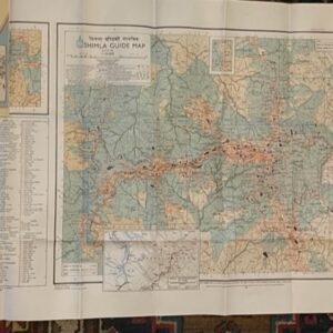
SHIMLA. A large scale guide map. surveyed in 1968
£
35.00
Add to cart
Add to shipping quote
←
1
2