View cart “Egypt, Arabia Petraea. A late 19th century folding map.” has been added to your cart.
Sale!
European Railway map, Vienna 1861
£165.00£150.00
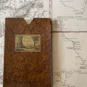
R. A. Schultz: Praktische Geschäfts und Reisekarte Sämmtlicher Staaten von EUROPA … mit Angabe der Distanzen der bestehenden Eisenbahnen. European Railway Map. Artaria & Co. Wien 1861.
A good and large railway map of Europe, dissected, linen backed, and coloured in outline, extending to a size of 39 x 51 inches when unfolded. The map is generally clean and sound with just a little occasional discolouration and two small ink blots in the sea just to the south of Sardinia. It folds down in 50 plates to a size of 8 x 5 inches when it fits into its original quarter leather gilt card slip case, the boards covered with marbled paper. There is also a matching protective chemise into which the map fits. The spine is titled EUROPA and the base of the case has some wear along the bottom edges. The map extends to the sea beyond the northernmost parts of Scandinavia and Iceland is shown. The coastal areas of Morocco, Algeria and Tunis appear at the bottom of the map and to the east the island of Crete with parts of Anatolian Turkey. It also includes most of the Caspian Sea. One of the endplates has an advertising list of Artaria’s maps to the verso. feb26/3