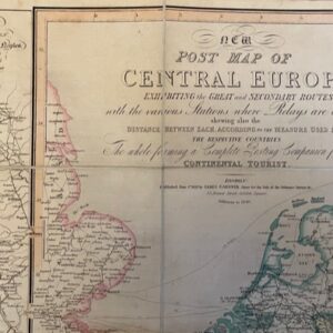
View cart “An 1840 folding map of Central Europe the tourist” has been added to your cart.
Sale!
ITALY. A route map of Italy, published in Paris in 1824
£190.00£170.00
Carte Routière de l’Italie indiquant les Divisions politiques des divers États. Dressée en 1820 par A. H. Brué, Géographe à Paris. Chles. Simmoneau [Paris] 1824.
A handsome and well produced folding map of Italy, dissected and linen-backed, 31 x 50 ins unfolded and folding down to a size of 8½ x 5ins and fitting into its original chemise and green and gilt slipcase titled on the spine ITALIE, a little wear to extremities of the case and the spine faded but an excellent copy of a Grand Tour map. The map shows the whole of Italy in detail as well as Switzerland coloured in outline, along with the Dalmatian Coast and the islands of Sardinia and Sicily. The original map seller’s label of T Goujon of Paris to the linen backing of an end plate. mar12/1