")
")
")
")
")
")
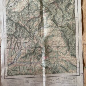
NAINI TAL & GARHWAL 1 inch map of 1894 in use by a hunter in the 1940s
POA
Thuillier, Colonel H. L.. C.S.I., F.R.S. Surveyor General: United Provinces, India. Parts of Districts Naini Tal & Almora. Folding Map No 53 O/12 & 16 (Old No. 251) Seasons 1872-73 & 1888 to 1890. Survey of India [Calcutta] 1894. SOLD 23rd July 2026
Folding black and white map, dissected, linen backed, 37 x 27 ins on a scale of 1 mile to 1 inch, folding down to a size of 12 x 8ins with cloth endpapers retaining printed label. There is some old writing on parts of the map in red and blue ink showing its use on a hunting or shikari trip following the Nandhaur River from Chorglia to Aunla ka Khera starting from the railway station at Haldwani taken in March 1945 & 1948. oct27/5
It is a tribute to the very high standard of 19th century surveying in India that these maps were still in practical use by travellers and big game hunters 70 years later.
Sold